Maps made in the time of Shakespeare to be displayed in Shropshire
Maps made in the time of Shakespeare will be among those going on display at a book shop this weekend.
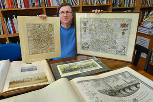
An annual exhibition of rare and important maps of Shropshire, Herefordshire and Radnorshire, some dating back to the 16th century, will open at Aardvark Books, at Manor Farm in the village of Brampton Bryan, near Bucknell, tomorrow. It runs to May 14.
Among them are some drawn up to accompany a poetic tour of England and Wales by Shakespeare's friend Michael Drayton in 1612 and 1622.
The maps, by William Hole, were included in the two parts of Drayton's 'Poly-Olbion', a journey through the landscape, history, traditions and customs of England and Wales at the time, written in verse. The exhibition is not the first for the bookshop on the Shropshire border between Leintwardine and Knighton – it has held five such 'comprehensive cartographic reviews' previously.
This time the exhibition is called Maps and Mansions, and will include 18th and 19th century artwork showing views of significant country houses from the border counties.
For the first time it will also be showing the Johannes Blaeu maps of Shropshire, Herefordshire and Radnorshire together.
Bookshop owner Sheridan Swinson said: "There will be an opportunity to see rare first editions of Hole's early 17th century maps made to accompany The Poly-Olbion. This long topographical poem describes England and Wales, with references to both contemporary science and ancient Arthurian mythology. The exhibition includes two Poly-Olbion maps of Shropshire, together with the map of Herefordshire and Worcestershire.
"The exhibition also includes an early example of the Humphrey Llwyd map of Wales from 1574, a year after its original publication, which has very early – possibly contemporary – colouring," he said.
He said history and cartography buffs could also come and see first editions by major names in map making such as Ogilby and Speed, along with large Blome maps of Herefordshire and Shropshire, and maps by Janssen, Harrison, Cary and Bowen. Among the highlights are prints and sketches put together by 19th century Shropshire MP Stanley Leighton

