Met Office weather warning issued for heavy rain and thunderstorms this Sunday
The Met Office has issued a yellow weather warning for heavy rain and thunderstorms coming to the region on Sunday.

On Sunday, June 18, heavy rain and thunderstorms are expected to cause disruption to parts of England and Wales.
The weather warning follows days of of heavy thunderstorms and flash flooding hitting the region at the beginning of the week, affecting schools, pubs and homes across Shropshire.
Shropshire Fire and Rescue Service crews were called out multiple times on Monday to floods in Ellesmere and Much Wenlock after the heavens opened and roads filled quickly with standing water.
Shropshire Council said that about 25 homes and business in Much Wenlock High Street had been affected.
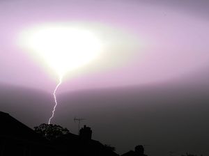
Then on Tuesday a lightning bolt hit a Severn Trent Water booster station near Church Stretton.
The high temperatures and humidity have been followed by heavy rain and thunderstorms for several days and now it is set to return on Sunday, according to the Met Office.
In the weather warning the Met Office says:
What to expect:
Spray and sudden flooding could lead to difficult driving conditions and some road closures
There is a small chance that homes and businesses could be flooded quickly, with damage to some buildings from floodwater, lightning strikes, hail or strong winds
Where flooding or lightning strikes occur, there is a chance of delays and some cancellations to train and bus services
There is a slight chance that power cuts could occur and other services to some homes and businesses could be lost
There is a small chance that some communities become cut off by flooded roads
"Heavy showers and thunderstorms are likely to develop across parts of England and Wales during Sunday, with longer spells of thundery rain in places.
"Whilst many areas will see at least some rain, most will see only relatively small amounts.
"However, some places could see 30 mm in an hour and 60mm in 6 hours, with the potential for frequent lightning, strong winds and hail.
"Where this occurs there is likely to be some disruption.
"While there is a high likelihood that thunderstorms will develop over England and Wales, there remains a large amount of uncertainty in exactly where these develop."


