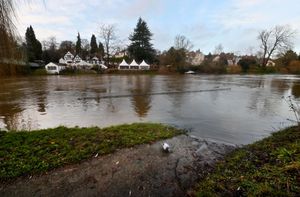
Shropshire river levels yet to reach their peak after Storm Gerrit battering
River levels are now expected to peak in the county over the weekend and on Monday after a battering from Storm Gerrit.
Watch more of our videos on ShotsTV.com
and on Freeview 262 or Freely 565
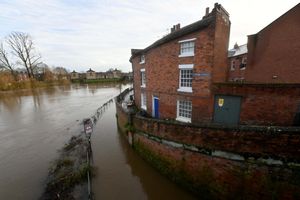
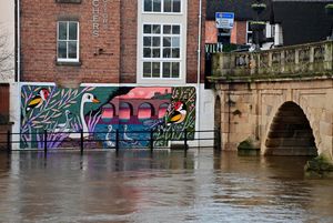
Flood defences were put up in Shrewsbury and Ironbridge earlier this week as the Environment Agency prepared for the impact of the swollen River Severn. A flood warning issued for Shrewsbury on Thursday afternoon said that flooding of property, roads and farmland is "expected" and that the river is likely to peak at the Welsh Bridge on Monday afternoon.
A flood warning was issued for The Quarry and The Showground in the county town on Thursday evening after a day of heavy rain.
As of the latest update on Friday, levels in Crew Green and Shrewsbury were predicted to hit their peaks of 6m to 6.2m and 3.2m to 3.8m respectively on Sunday and Monday afternoon.
Slightly lower peaks have now been forecast for Ironbridge at 4.8m to 5.2m tomorrow afternoon, and Bridgnorth at 4.0m to 4.3m, also on Saturday afternoon.
It comes after the county was hit by extremely strong winds and rain from Storm Gerrit early yesterday morning.
The storm uprooted trees and also appears to have been responsible for a huge 'bang', heard in Bridgnorth – with residents describing the noise as like an "explosion".
The boom was heard around 10.50pm on Wednesday, and was accompanied by a bolt of lightning.
Caroline King who lives in Low Town explained how it had even destroyed her internet connection.
She said: "There was a massive lightning bolt through my windows and then a massive bang. My WiFi router has blown from it. It is still out now and I won't be back online until next Wednesday, which affects me as I work from home. My power hasn't been affected but I believe it has been for a lot of residents in Low Town."
Meanwhile the Environment Agency has urged people to take caution around the rising rivers amid the festive celebrations.
Chris Bainger, the Environment Agency Fisheries Technical Specialist for Shropshire, Herefordshire, Worcestershire and Gloucestershire, posted an update on social media saying: "A reminder please, with the festive period coming please stay away from swollen rivers and standing water, it is not a safe place to be."
A motorist also had to be freed by fire crews after their vehicle got stuck in water during heavy rain near Telford.
The incident at around 1.30pm yesterday near the former Grove Inn pub in Walcot saw a fire crew from Wellington attend.
A spokesman for the Shropshire Fire and Rescue Service said the vehicle was hauled free from the water using the fire engine.
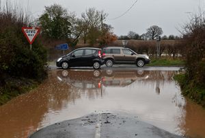
Meanwhile flood warnings were still in place for Melverley and Maesbrook, with less severe flood alerts for the Rea Brook and Cound Brook, the Dee catchment from Whitchurch to Chester, the River Lugg north of Leominster, the Severn throughout Shropshire, and the Severn/Vyrnwy confluence and Tern and Perry Catchments.
More rain is also forecast for this weekend.
The Met Office says 2023 will end on an unsettled note with strong winds and rain returning to the UK.
During the early hours of Saturday they say a potentially deep area of low pressure will move in from the west to affect Ireland and western parts of the UK.
At the moment it doesn't look like snow will be a feature in the Midlands though. But they say a band of "transient snow" could be a feature further north.