12-hour thunder weather warning issued as temperatures continue to climb
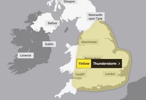
The Met Office has issued a 12-hour yellow weather warning for later this week when thunderstorms are expected across the UK.
Watch more of our videos on ShotsTV.com
and on Freeview 262 or Freely 565
After a glorious beginning to the week with temperatures reaching as high as 26C (78.8F), heavy thunderstorms and showers are expected to develop towards the weekend.
The warning has been issued from midday until 11.59pm on Thursday and covers much of the country, including Shropshire, parts of Powys, Herefordshire, Staffordshire and the Black Country.
In their warning, forecasters say: "Heavy showers and thunderstorms are likely to break out across parts of England and Wales on Thursday afternoon.
"The exact location of showers is still uncertain and some places will stay dry all day. However, where the showers do occur they could be torrential, with the additional hazards of lightning, hail and gusty winds."
"The heaviest showers could result in 20-30 mm within an hour, with 24 hour accumulations possibly reaching as much as 70-90 mm where multiple showers affect the same location."
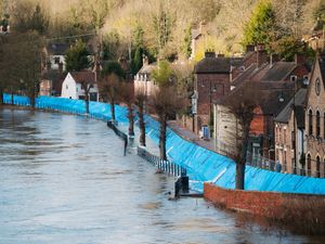
The Met Office says the weather could cause some disruption including flooding that could cause road closures, travel delays and cancellations, and power cuts.
Met Office spokesperson Nicola Maxey warned: "As we move into the middle of the week we start to see an increasing risk of thunderstorms developing, particularly in parts of England and Wales, and the rain is such that it could cause some local disruption.
"This is the sort of rainfall that could cause surface water flooding and heavy rain that takes a while to clear away.
"There could also be some lightning potential for hail and gusty conditions."
The warning covered most of England and parts of Wales, stretching from the south coast up through the Midlands and the Welsh border, going up to reach as high as Newcastle.
Meanwhile, the rest of the week is looking rather bright and sunny, and residents across the county can expect the warm weather and sunshine to last.
The Met Office has warned that UV levels will remain very high throughout this week - expected to reach as as seven on Tuesday and Wednesday.
Tuesday expected to be clear with temperatures peaking 28C (82.4F) in the county, while Wednesday could be as hot as 31C (87.8F) despite some cloud forecast for the afternoon.

After Thursday's yellow weather warning, where it will remain warm, Friday is set to bring sunny intervals before it will be partly cloudy by night-time before temperatures are set to cool during the weekend and reach as high as 22C (71.6F) on Saturday and 21C (69.8F) on Sunday.
As always, remember to stay safe in the sun.
Further information can be found at: https://www.metoffice.gov.uk/