Flooding: Latest alerts, river levels and damaged roads as flood barriers go up
Several flood alerts remain in place and barriers have gone up as the county recovers from a downpour earlier in the week.
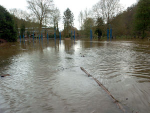
Heavy rain on Wednesday caused chaos on Shropshire's road and rail network, and preparations are now underway to deal with the aftermath along the county's waterways.
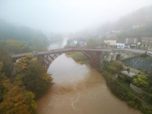
On Thursday, barriers went up in Shrewsbury's Frankwell car park while the Environment Agency (EA) announced flood barriers would be deployed along the Wharfage in Ironbridge.
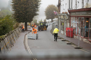
On Friday at around 2pm, EA crews began to install the barriers along a 250m stretch of the Ironbridge road.
A spokesperson said: "Initially 250 metres of 1.8m high barriers are being deployed. Further barriers will be deployed over the weekend if we need them."
The latest figures show river levels around the county remain high as a result of the heavy rainfall, and flooding of property, roads and farmland is expected.
Along the Severn, levels are falling at the Crew Green gauge, with levels at Montford expected to reach between 5.7m and 5.9m on Friday.
Levels at the Welsh Bridge in Shrewsbury were predicted to peak between 3.3m to 3.6m on Friday afternoon - around half a metre higher than the top of the 'normal' range of 2.7m.
Flooding of the West Mid Showground and Gravel Hill Lane is expected.
River levels at Buildwas are expected to reach between 4.8m and 5.2m on Saturday - that is just under a metre higher than the top of the 'normal' range of 3.4m.
The Severn is then likely to reach between 4m and 4.3m on Saturday in Bridgnorth. The top of the 'normal' range here is 3.6m.
The government agency is warning residents that further rainfall is expected over the next 24 hours.
Flood warnings - where flooding is expected - remain in place elsewhere in the county too, including for the River Teme at Eardiston, Leintwardine and Walford, Standford Bridge, Tenbury Well and Burford, as well as the River Vyrnwy at Maesbrook.
Flood alerts - where flooding is possible - are in place for the Ledwyche Brook and River Rea, Lower Teme, Rea Brook and Cound Brook, River Dee from Whitchurch to Chester, River Lugg north of Leominster, River Sow and River Penk, River Worfe, the Severn Vyrnwy confluence, Tern and Perry catchments and Upper Teme.
The Shropshire primary schools that were closed yesterday due to flooding have now reopened.
On Thursday, Bishop's Castle Primary, Clunbury, Newcastle CE Primary School, St George's in Clun, St Mary's in Bucknell, Wistanstow, Chirbury, Norbury, Onny in Onibury and Stiperstones were all closed for the day.
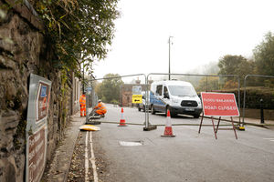
Just over the border in Powys, the county council was warning that some roads remain closed after they were damaged by floodwater.
A spokesperson for Powys Council Council said: "Significant disruption was caused with a number of roads closed due to floodwater while landslides and fallen trees also impacted the road network.
"Drains and culverts became overloaded due to the volume of rainwater that fell in the county in just a few hours.
"Some roads remain closed due to flooding and won't re-open until the water has receded. Two roads, the B4393 near Llansantffraid and the B4520 near Upper Chapel, are open under traffic management after they were damaged by floodwater."