Group explores route of Shrewsbury's proposed North West Relief Road
A group of residents joined together to see for themselves the planned route of the North West Relief Road.

Many felt there was confusion over the exact rout the proposed road would take.
Mike Streetly of Better Shrewsbury Transport, an alliance of local organisations that arranged the visit, said: "So we thought this would be as a good way of seeing the whole environment."
See also:
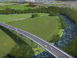
The route of the proposed road will cut across the green wedge of countryside which reaches into town and is easily accessed from several neighbourhoods. The group used Corporation Lane to get out into the countryside which still has features created in the ice age: a kettle hole formed as a result of blocks of ice left behind by a retreating glacier; the Old River Bed where the Severn ran before the glaciers forced it to change course and which is rich in wetland plants; glacial moraine.
“We had refreshments under an ancient oak on the moraine ridge high above Shrewsbury where the road would go, and had a wonderful view of the town," said Claus Best, one of the participants.
“But it makes you understand how the noise of the new road will become a constant background to the life of the town. We finished at Hencott Pool which is a Ramsar site - a wetland of international importance."
Unique
Shropshire Council has earmarked the eastern end of the new road as potential space for thousands of new homes, with the road providing for the extra cars. “Shrewsbury is almost unique as a town in England having this rich and accessible “green wedge” of historic environment which we can easily walk out into," said Claus.
“If we’re trying to attract people and businesses, we somehow have to come up with plans which don't destroy one of its most beautiful features."
Other walkers were concerned about a possible increase in traffic congestion.
Jan Dale, a resident of Coton Hill, said: “At first I thought the road would be great and give me a chance to drive around more easily. But now I realise that the links from the new road into Berwick Road and Ellesmere Road will increase traffic at peak times and actually make congestion worse.
"Also air pollution in Coton Hill is already bad and we will get even higher levels. I'm equally concerned that the flyover proposed for the river will be unsightly and carry traffic noise into town, and the unspoiled countryside around Coton Hill will be lost."
Shrewsbury Civic Society is offering everyone the chance to hear discussion for and against the new road at an event on November 30 1.30pm - 5pm at the University Centre Shrewsbury. Another walk is planned to see part of the Oxon Link Road section in Bicton, on Saturday starting at 10am from Bicton Village Hall and everyone is welcome.
A map of the route can be found at bettershrewsburytransport.org


