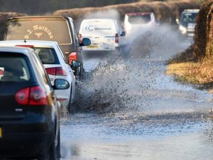
Shropshire on flood alert as heavy rain lashes county
Parts of Shropshire were warned to expect flooding today as rain continued to batter the region.

Communities in Ludlow, Bishop's Castle, Church Stretton and Knighton could be hit by flood water from the River Teme, River Onny and River Corve as their banks swell.
It could mean low-lying roads and fields could be under water this week as rain continues to fall, and walkers have been told not to venture onto footpaths near watercourses.
In Hope Bowdler, near Church Stretton, a fallen tree had to be removed after it blocked part of the main road through the village.
The Met Office warned downpours would sweep across the region though Tuesday into Wednesday as it issued a yellow warning for heavy rain.
Central Motorway Police Group tweeted to say rain was causing delays on the region's motorways and warned drivers to "watch out for standing water".
The government flood warning system said: "Flooding of roads and farmland is possible from Tuesday morning until Wednesday. We believe there is a possibility of flooding for low lying land and roads adjacent the River Teme, River Onny and River Corve and their tributaries.
"Further bands of heavy rainfall are forecasted over the next few days until June 13 [Thursday]. We are closely monitoring the situation. We expect river levels to begin rising this afternoon.
"Our incident response staff are clearing weed screens and checking defences. Please avoid using low lying footpaths near local watercourses and see the gov.uk website for a five day flood forecast."
To view the latest flood information, visit https://flood-warning-information.service.gov.uk/warnings
Other parts of the UK were predicted to see more than 100mm of rain this week.
On Monday evening, heavy flooding in Kent closed all lines through Orpington railway station for several hours, while police shut a section of the M25 overnight after discovering two sinkholes on the central reservation.
The motorway was closed in both directions and Highways England warned it was expected to remain shut throughout Tuesday morning's rush hour.
See the Met Office's latest forecast here:
National Rail has also warned that Southern and Thameslink trains will be heavily impacted during the morning commute, with some services delayed or cancelled due to flooding.
North-eastern parts of England and the Midlands are expected to bear the brunt of the downpours on Tuesday, with a yellow warning in place until midnight.
Some areas set to see up to 60mm of rain, particularly over the first half of the day, according to the Met Office.
On Wednesday and Thursday, some parts of the UK could be struck by 60mm to 80mm of rain, and possibly even up to 100mm.
Met Office meteorologist Alex Burkill described the figures as the "worst-case scenarios" but added that people need "to be aware that we're in for some treacherous weather".
"If you add it all up some places are likely to see over 100mm this week, which is around double the average they would get in the whole of June," he said.


