
Thunderstorms warning for Shropshire
Thunderstorms are expected to strike in Shropshire this afternoon and evening after a warning was issued.
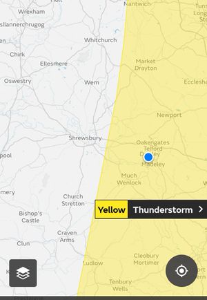
A yellow warning has been put out for the eastern part of the county, with Telford, Market Drayton and Ludlow among areas expected to take the brunt of the storms between 1pm and 9pm
The Met Office said: "Thunderstorms are likely to develop over parts of the Midlands and East Anglia today with some disruption to power and transport possible.
"There is a good chance driving conditions will be affected by spray, standing water and/or hail, leading to longer journey times by car and bus.
"Delays to train services are possible.
"Some short term loss of power and other services is likely"
It also said that there would probably be damage to a few buildings and structures from lightning strikes. and some flooding of homes and businesses is likely.
Watch the Met Office forecast for today:
Elsewhere in the country, parts of the UK could see almost a month’s worth of rain in the space of a couple of hours.
The Met Office has issued a thunderstorm warning for much of Scotland and northern England which is in place from midday until 9pm on Thursday.
Heavy showers may cause flooding and travel disruption, with forecasters warning there is a small chance of fast-flowing or deep flood waters causing danger to life.
Meteorologist Emma Smith said 30mm of rain could fall in one hour, while 50mm could fall in two to three hours.
The average amount of rainfall in July for the UK as a whole is 70mm, while the July average for England is 55-56mm – meaning that almost a month’s worth of rainfall could fall in a couple of hours on Thursday.