Bridgnorth housing row: Campaigners' map shows potential size of site
A group opposed to plans for hundreds of new homes in Bridgnorth has created its own map to show the potential scale of the plans.
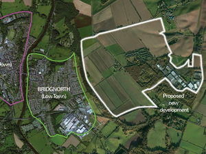
The Save Bridgnorth Green Belt group has released the image as it seeks to publicise Shropshire Council's plans for development in the town.
The map includes an area of the town which is earmarked for development up to 2036 and beyond.
The council is currently consulting on its plan for a garden settlement and employment land which could be built over 40 hectares of land at Stanmore.
The plan, which proposes building 850 homes on the site, would be developed up until 2036.
A large section of green belt surrounding the site is also being set aside for further development after 2036.
The council's document on the plan says "justifiable exceptional circumstances exist" for the release of green belt land which would outweigh the impact.
MORE:
The action group has warned that the whole site would be a settlement the size of High Town in Bridgnorth.
The group has also encouraged people to respond to the council consultation on the plans before the deadline of February 8.
Peter Wilson, local resident and group member said, “The impact on local residents and the Greenbelt, which is vital to protect the countryside, will be disastrous. But this isn’t just about Stanmore. The impact on Bridgnorth town will also be enormous.
"The infrastructure would be overwhelmed - doctors, schools, hospital, traffic, parking – and Shropshire Council admit there are no guarantees of any investment to address it.
"We’re finding that people in Bridgnorth are simply unaware of the scale of the proposed changes the council want to push through, and time is running out before the consultation closes.
"We’re appealing to people to speak up now, before Bridgnorth and our countryside is ruined forever."

