Flooding feared as heavy rain and strong gusts hit parts of UK
Much of southern, central and eastern England plus South Wales is covered by a rain or wind warning on Thursday

Heavy downpours and strong gusts could bring flooding and disruption to parts of England and Wales on Thursday.
A yellow warning for rain is in place across the West Midlands, South Wales and south-west England until 2pm with some places forecast to see 20-30mm of rain, according to the Met Office.
The warning states: “A band of heavy rain and squally winds will move east across South Wales and south-west England early on Thursday morning, with further heavy rain at times until early afternoon.
“Some places will see 10-15mm of rain within 2 hours and a few places could have 20-30mm of rain during the period of the warning.”

Great Western Railway (GWR) said flooding had disrupted services near Totnes, Devon. No services were expected to run from Plymouth to Exeter St David’s until after 10am on Thursday with a very limited service in the other direction.
It came as the 12-hour rainfall totals on Wednesday included 68mm that was recorded at Whitebarrow on Dartmoor and 63mm at Coniston Coppermines, Cumbria.
Much of southern, central and eastern England is covered by a rain or wind warning meaning that “after what has been a wet February so far, further rain is on the way on Thursday, accompanied by some gusty winds”, according to Met Office chief meteorologist Paul Gundersen.
The Environment Agency (EA) has issued 39 flood warnings – when flooding is expected – and 203 flood alerts in England with National Resources Wales issuing three flood warnings and 28 flood alerts.
A band of rain that is expected to move east across England during Thursday, before clearing eastern England by early evening, means some regions should brace for possible flooding and disruption.
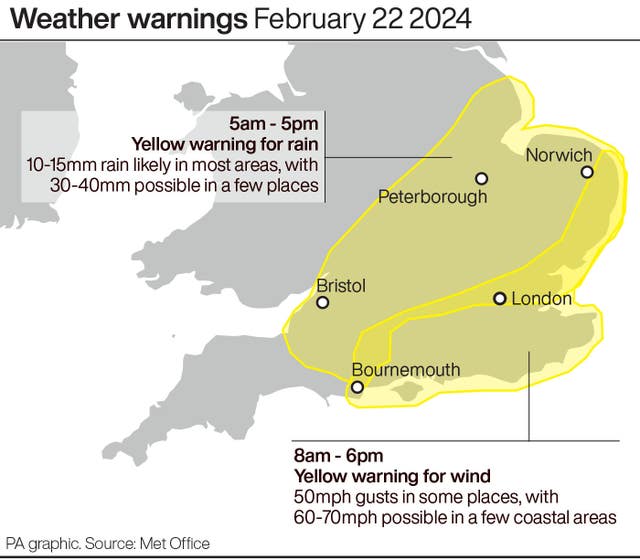
The Met Office has issued a yellow warning for rain covering the East Midlands, East of England, London and south-east England, the South West and West Midlands from 5am to 5pm on Thursday.
It states: “Rain will be heavy at times and perhaps become more prolonged to give 3-6 hours of rain.
“Most places within the warning area will see 10-15mm of rainfall but a few places could see 30-40mm with this falling onto already saturated ground.
“Lightning and gusty winds are likely to be additional hazards, with a small chance of gusts around 50mph in a few places.”
A yellow warning for wind is also in place for Thursday from 8am to 6pm, with “gusts of around 50mph in a few places very briefly, as well as some hail and thunder”.
The East of England, London, the South East and South West are the regions which have been urged to brace for “a small chance of disruption from strong winds”.
The wind warning also states: “There is a small chance of a broader swathe of very strong winds affecting southern and eastern England with gusts of 60 to 70mph, mostly likely close to English Channel and southern North Sea coasts.”
Mr Gundersen added: “There’s a small chance that wind gusts could reach 60-70mph, mostly likely on exposed coasts, though more widely we’re likely to see a shorter spell of heavy, squally rain with hail and thunder in a few places and gusts to around 50mph.
“Most places within the warning areas are likely to see 10-15mm of rain, with a chance of 30-40mm in a few places. This is falling on saturated ground, which elevates the chances of flooding and disruption.”


