
Thunder, lightning and hail strike the UK in dramatic end to summer season
The autumn equinox takes place on Sunday afternoon, marking the end of summer and the start of autumn.

Thunder, lightning and hail have struck parts of the UK in a dramatic end to the summer season.
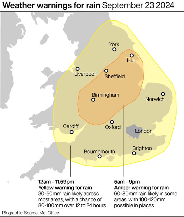
A weather warning for rain has come into force lasting all of Sunday for Wales and central south-west England, with a further two rain warnings – one yellow and one amber – coming into effect on Monday.
The yellow warning, lasting all day, will stretch to cover areas further east and further north while the amber warning, up between 5am and 9pm, focuses on the areas of Birmingham, Peterborough, Stoke-on-Trent and Hull.
The autumn equinox takes place on Sunday afternoon, marking the end of summer and the start of autumn, with forecasters warning of continued unsettled weather, and potentially more warnings, for the start of the new season.
According to the Met Office, thunderstorms moved across the country on Saturday, starting in Cornwall before striking more central, towards the north-east of London, and then up through Birmingham and towards the East Midlands.
Around midnight, there was a “plume” around Northampton, Peterborough and near Leicester.
Lightning in Great Oakley, Corby, Northamptonshire, at around 1am was captured by local resident Jenna Smith who posted snapshots of the “cracking” strikes on social media.
In the early hours of the morning, there were thunderstorms to the far north and south of London and some “creeping up” towards the Bournemouth coast.
The weather led to road closures in Hertfordshire and Bedfordshire as a result of flooding and travel disruption between Penzance and London Paddington, and Penzance and Truro, after flooding on the railway between Redruth and Camborne.
Between 2pm on Saturday and 7am on Sunday, Longcliffe in Derbyshire saw 67.6mm of rain, while Creswell in Staffordshire and Evington in Leicestershire got 65mm and 60.4mm respectively.
Met Office meteorologist Honor Criswick said she had “no doubt” the conditions led to damage and localised flooding in places after rain, thunder and “quite significant outbreaks of quite large hail”.
There are three flood warnings in place in England for waters in north-west Leicestershire, south Staffordshire and Bedfordshire.
Sarah Cook, flood duty manager at the Environment Agency, said: “Persistent heavy rain and thunderstorms could lead to significant surface water flooding on Monday across parts of England.
“The impacts could include localised flooding in urban areas and fast responding catchments, including some property flooding as well as travel disruption. The risk from river flooding remains low.”
She added: “We urge people to plan their journeys carefully, follow the advice of local emergency services on the roads and not to drive through flood water – it is often deeper than it looks and just 30cm of flowing water is enough to float your car.”
Ms Criswick said: “Where we’ve had the rain over the last couple of days we’re expecting further rain for the beginning of next week as well.
“We have just recently issued an amber warning as well for similar areas across parts of the Midlands and also just moving up into the north-east of England as well.
“So where we’ve seen accumulation of rain over the last day or so we’re expecting further rain as well.
“It’s likely we’ll see more impacts from flooding and road closures and things like that.”
According to the meteorologist, some affected areas could see 100 to 120mm of rain on Monday.
But parts of Scotland, Ireland and north-west England might see a slightly better day and there should be a mixture of sun and showers in south-east England.
Tuesday is expected to see a “bit of a swap” where northern areas and parts of Scotland are likely to see longer spells of rain whereas much of the south, Wales and the Midlands should see a largely dry day.
“From Wednesday onwards still very unsettled outbreaks of rain, some brisk winds at times and likely to see further warnings in the week I would say,” Ms Criswick said.


